ITA
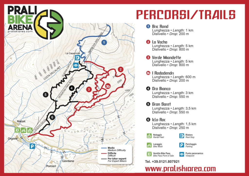
Lunghezza: 1,55 km
Dislivello: 200 m
Indicato per bambini e principianti. Composto da curve semplici e piccoli salti.
ENG
Length: 1,55 km
Slope: 200 m
Suitable for children and beginners. It alternates easy curves to small jumps.
ITA
Lunghezza: 5 km
Dislivello: 800 m
Si sviluppa sul tracciato di un vecchio sentiero usato dai malgari per salire agli alpeggi con il bestiame. Il percorso, completamente naturale, alterna tratti di discesa veloci e altri più tecnici.
ENG
Length: 5 km
Slope: 800 m
This trail has been developed over an old path that was walked by herders going uphill with their cattle. Completely natural, this trail consists of fast descents mixed with more technical passages.
ITA
Lunghezza: 1,0 km
Dislivello: 200 m
Variante della Verde Miandette.
ENG
Length: 1,0 km
Slope: 200 m
Another version of the Verde Miandette trail.
ITA
Lunghezza: 5 km
Dislivello: 800 m
Destinato agli amanti del freeride, il percorso è composto da salti, curve paraboliche e toboga.
ENG
Length: 5 km
Slope: 800 m
Recommended to freeride enthusiasts. It presents a fun sequence of jumps, parabolic curves and toboga.
ITA
Lunghezza: 3,5 km
Dislivello: 550 m
Lungo un sentiero che in passato veniva usato dai boscaioli di Prali, il tracciato segue la pendenza naturale della montagna addentrandosi nel bosco del Gran Saret.
ENG
Length: 3,5 km
Slope: 550 m
In the past, this trail was used by local woodsmen. It follows the natural slope of the mountain while gradually entering the Gran Saret forest.
ITA
Lunghezza: 3 km
Dislivello: 550 m
Una downhill pura che sfrutta la forte pendenza naturale e inventa linee e salti su rocce e avvallamenti della montagna. Alcune varianti la rendono adatta anche ai meno esperti.
ENG
Length: 3 km
Slope: 550 m
Purely downhill style. This trail takes advantage of a strong natural slope and alternates lines and jumps. There are other variants of this trail that are more suitable for beginners.
ITA
Lunghezza: 1,5 km
Dislivello: 250 m
Un tracciato tecnico e veloce destinato a biker con esperienza e di livello intermedio.
ENG
Length: 1,5 km
Slope: 250 m
This is a fast and technical trail, which is recommended to expert bikers with intermediate skills.
Hotel
Per visualizzare i contenuti come le mappe personalizzate, i video di YouTube e altro è necessario accettare l'uso dei cookie.
Per visualizzare i contenuti come le mappe personalizzate, i video di YouTube e altro è necessario accettare l'uso dei cookie.
Ristoranti
Per visualizzare i contenuti come le mappe personalizzate, i video di YouTube e altro è necessario accettare l'uso dei cookie.
Per visualizzare i contenuti come le mappe personalizzate, i video di YouTube e altro è necessario accettare l'uso dei cookie.


